
I don’t recommend going into a hunting unit blind, but that’s exactly what I did two years ago in Colorado. An old friend of mine and I had decided to put in for a 2nd choice area that neither of us had ever hunted. Our summer’s got very busy, schedules changed, and we didn’t have a chance to make it down to put our boots on the ground and see the actual lay of the land. But we have Google Earth right???
Believe me; I spent plenty of time on Google Earth looking at the unit. My background is in mapping and GIS technologies, so I was able to download a public land map and had a simple overlay in Google Earth that showed me chunks of public (and private) ground. I identified an area that looked great. It was back away from the roads a few miles, and it looked like perfect country for a couple of big muley bucks to live in. The closest road ended in the bottom of the canyon. According to my map, and the USGS maps – the very bottom of the canyon was private ground. I thought we could easily skirt around it and hump up the mountain into my chosen area.
Opening morning found us up dark and early, hiking briskly to get to our area before shooting light. Unfortunately – our maps were wrong. This private section was almost 3 times larger than shown on the maps I had. Needless to say, because we had to go so far out of our way, we didn’t make it in time. I know I should have been there before the hunt started to make sure I knew how long it took to get into my area– but I didn’t. The following year I had a new tool in my arsenal to try – a GPS chip from Hunting GPS Maps (OnXMaps). I was archery hunting in western Wyoming, where there are large plots of BLM land interspersed with a private, and some National Forest. Whether driving or hiking, knew exactly where we were, and what land type we were on. It was extremely accurate, and allowed us to harvest bucks in a few areas that we wouldn’t have otherwise due to poor property markings. Now I never hunt without it. I use it in a fairly inexpensive GPS (Garmin Etrex 20) and it’s as simple as inserting the SD card, making sure the proper layers are showing and going hunting. It shows me public vs. private, as well as all of the landowner names, and is updated very often. I was wishing I had a Colorado Chip the previous year…

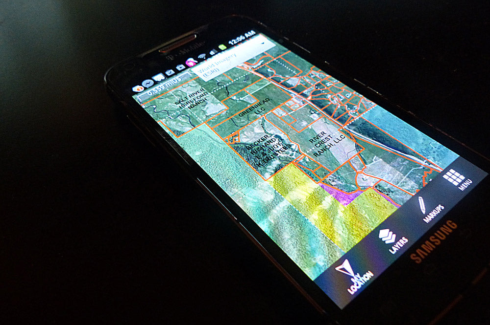
 This year I had the chance to use the new “Hunt App for Mobile” from OnXMaps and have been very impressed. It was simple to download onto my phone, login, and start browsing immediately. Many of today’s smart phones and mobile devices have built in GPS antennas; it’s like turning your phone into an incredible touch screen GPS unit, full of high resolution maps and detailed land ownership information. I find myself looking at this often during my downtime to look into new areas, or even new ways into old areas.
One of the most important things about this app is the ability to “cache” information. Most of my hunting areas are backcountry where no cell service and especially no data plans are available. This feature allows me to look at my area before heading out, and my phone will save the data, so I can view it on the mountain, even if I don’t have service. My only concern now is that I need a bigger battery for my phone!
This year I had the chance to use the new “Hunt App for Mobile” from OnXMaps and have been very impressed. It was simple to download onto my phone, login, and start browsing immediately. Many of today’s smart phones and mobile devices have built in GPS antennas; it’s like turning your phone into an incredible touch screen GPS unit, full of high resolution maps and detailed land ownership information. I find myself looking at this often during my downtime to look into new areas, or even new ways into old areas.
One of the most important things about this app is the ability to “cache” information. Most of my hunting areas are backcountry where no cell service and especially no data plans are available. This feature allows me to look at my area before heading out, and my phone will save the data, so I can view it on the mountain, even if I don’t have service. My only concern now is that I need a bigger battery for my phone!
 If you’re a DIY hunter like I am, I think the GPS Chips and the new mobile apps are an incredible tool, both in the field, and when planning your hunts. I use Google Earth often to plan hunts and look at where I’ve been. OnXMaps also produces Google Earth overlays that provide the same information for use on your home computer. All of these products are updated often, the team at OnXMaps does all they can to get the most accurate information available – so you won’t be expecting to be able to bypass or skirt around a piece of private land, only to find it different than expected.
While nothing replaces putting your boots to the ground and setting foot in your hunting areas, these great tools from OnXMaps will give you a head start to help you spend your precious time in the field in the most efficient way.
For more information or to purchase, check out On X Maps' website.
If you’re a DIY hunter like I am, I think the GPS Chips and the new mobile apps are an incredible tool, both in the field, and when planning your hunts. I use Google Earth often to plan hunts and look at where I’ve been. OnXMaps also produces Google Earth overlays that provide the same information for use on your home computer. All of these products are updated often, the team at OnXMaps does all they can to get the most accurate information available – so you won’t be expecting to be able to bypass or skirt around a piece of private land, only to find it different than expected.
While nothing replaces putting your boots to the ground and setting foot in your hunting areas, these great tools from OnXMaps will give you a head start to help you spend your precious time in the field in the most efficient way.
For more information or to purchase, check out On X Maps' website.
The following year I had a new tool in my arsenal to try – a GPS chip from Hunting GPS Maps (OnXMaps). I was archery hunting in western Wyoming, where there are large plots of BLM land interspersed with a private, and some National Forest. Whether driving or hiking, knew exactly where we were, and what land type we were on. It was extremely accurate, and allowed us to harvest bucks in a few areas that we wouldn’t have otherwise due to poor property markings. Now I never hunt without it. I use it in a fairly inexpensive GPS (Garmin Etrex 20) and it’s as simple as inserting the SD card, making sure the proper layers are showing and going hunting. It shows me public vs. private, as well as all of the landowner names, and is updated very often. I was wishing I had a Colorado Chip the previous year…
This year I had the chance to use the new “Hunt App for Mobile” from OnXMaps and have been very impressed. It was simple to download onto my phone, login, and start browsing immediately. Many of today’s smart phones and mobile devices have built in GPS antennas; it’s like turning your phone into an incredible touch screen GPS unit, full of high resolution maps and detailed land ownership information. I find myself looking at this often during my downtime to look into new areas, or even new ways into old areas.
One of the most important things about this app is the ability to “cache” information. Most of my hunting areas are backcountry where no cell service and especially no data plans are available. This feature allows me to look at my area before heading out, and my phone will save the data, so I can view it on the mountain, even if I don’t have service. My only concern now is that I need a bigger battery for my phone!
If you’re a DIY hunter like I am, I think the GPS Chips and the new mobile apps are an incredible tool, both in the field, and when planning your hunts. I use Google Earth often to plan hunts and look at where I’ve been. OnXMaps also produces Google Earth overlays that provide the same information for use on your home computer. All of these products are updated often, the team at OnXMaps does all they can to get the most accurate information available – so you won’t be expecting to be able to bypass or skirt around a piece of private land, only to find it different than expected.
While nothing replaces putting your boots to the ground and setting foot in your hunting areas, these great tools from OnXMaps will give you a head start to help you spend your precious time in the field in the most efficient way.
For more information or to purchase, check out On X Maps' website.


Leave a comment